Someone said something to me the other day which put me in mind of a mysterious little opening into the walls at the Shore Gate which I thought I might like to see if I could get into.

Shoregate with the cundie opening to the right by the wheelie bin.
Now, I sometimes get asked about “the tunnels running under the streets of Berwick”. It is easy to dismiss such ideas but you shouldn’t: there may be a grain of truth in there somewhere. I remember a builder once telling me about how he had been doing some work in a cellar at the WH Smith shop in Marygate and how they came across a tunnel. “OK. Thank you for the information”, and you’re not sure what to make of it. But by complete co-incidence, another builder tells me a similar story about a tunnel under a property nearby. Now it’s getting interesting. Either the Berwick building trade is conspiring against me or there’s something in the stories.
Another tale you hear from older blokes goes along the lines of, “When we were kids we used to crawl up the tunnel by Coxon’s Tower. I don’t know where we got to but it branched out in two directions. I think we got to Silver Street because you could hear cars. Mind, I’d never do that now!" And neither would I!

Cundie leading out to near Coxon’s Tower.
Its still highly unikely that these are tunnels as we would picture them but I think what they took to be tunnels were part of a late mediaeval system of drains or "cundies”. Apparently, the word is still used in Dundee to mean the water drainage grills by a roadside kerb.
Somewhere I once read a reference (and I apologise for not being able to find it now) in the late 16th century (I think) to the problems the town is having with “waste” being swept from the upper parts of the town to the Hide Hill / Bridge Street areas. You get the impression that people and horses are knee deep in muck! Uurgh!!
No wonder then that a drainage system was built. Much later, The Board of Health produced a map based on the 1852 Ordnance Survey 1st edition map, showing drains in Berwick. Interestingly, some of these show as red dotted lines. This suggests that the exact alignment is unknown.
It does confirm the childhood memories of attempted potholing in Berwick, although I doubt they got as far as Silver Street! The tunnel opening can be seen at to the west of Coxon’s Tower as a hole in the walls about one meter square which goes up some way.
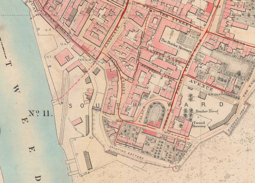
Detail from 1852 Board of Health map showing drains as red lines.
Another similar opening can be spotted at the Little Quay by the Chandlery near the Shoregate.

Little Quay, Berwick, showing the drain opening.
The Board of Health map doesn’t indicate this drain but suggests instead that it leads straight out to near where the slipway used to be. There is no evidence for any opening there now. However a military plan from 1810 does show it as a green line. How they missed this 40 years later is beyond me.

1810 plan showing drains as red lines. (Courtesy NMR)
Would I now want to get into this “tunnel”? Er, no and sadly I think I’m a little on the large side for exploring cundies these days.
As always, please let me know of any other mysterious tunnels or anything else you know of!
